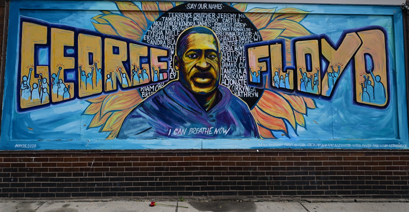
Sunday, May 25, marks five years since the killing of George Floyd.
In remembrance of his life and the response to his murder, Minnesota communities are coming together in celebration of the movement and mourning lives lost.
Here are some events:
Justice For George
The artist collective Memorialize the Movement is hosting its fifth annual Justice for George event that features art-making, large-scale mural exhibitions, music and dance performances over the course of five days. The theme of this year’s event is “Radical Joy,” which “encourages community care, connections, and healing, while continuing to grieve, mourn, and fight for a better future for Black communities.”
Thursday, May 22, and Saturday, May 24, from 7 to 9 p.m. at Pillsbury House + Theater, 3501 Chicago Avenue, Minneapolis, the organization hosts a free reading of the one-act play, “Kill Move Paradise.” The play, written by Pulitzer Prize winner James Ijames (Fat Ham), explores the brotherhood of murdered black men who “offer each other solace and reconciliation, as they prepare for ascension to paradise and their new roles as spiritual guardians and saints.” An open discussion will follow the performance. Registration for the event is required.
Friday, May 23, from 6 to 10 p.m. at 3140 Snelling Ave., Minneapolis, the organization hosts Paint to Express Summer Kickback. The free event features grilled food and painters workshops, which are hosted monthly by the organization to “provide the community with a safe space to express themselves creatively.” Registration is required.
Sunday, May 25, from 12 to 8 p.m. at Phelps Field Park, 701 E. 39th St., Minneapolis, the organization hosts the Justice for George main event, which features live performances, muralists, a vendor fair and other opportunities for community connection.
Registration and/or free tickets are required for these events. For information, visit memorializethemovement.com.
Rise & Remember Festival
The fifth annual Rise & Remember Festival serves to remember George Floyd and “those we have lost unjustly to the pervasive impacts of systemic racism,” according to their website. The three-day festival will include a candlelight vigil, a Night of Honor and street festival.
Friday, May 23, from 4:30 p.m. to 12 a.m. at Quincy Hall, 1325 Quincy St., Minneapolis, the Night to Remember gala, dinner and award ceremony will “celebrate the contributions of the people’s work toward racial justice” and feature live performances from comedian Hope Flood, DJ Sophia Eris, Maria Isa, Mr. Cheeks, The East Side Boyz and others. The dress code for the event is formal wear and sneakers. Tickets for the dinner and award ceremony, which begins at 4:30 p.m. cost $44.52. Tickets for the concert cost $81.88.
Saturday, May 24, from 10 a.m. to 6 p.m. at George Floyd Square, 38th Street East and Chicago Avenue South, Minneapolis, the street festival will kick off for day one of the two-day weekend event. From 10 a.m. to 6 p.m., a “self-care fair,” aimed at “providing opportunities for community members to experience integrative health practices,” will feature wellness vendors and practitioners, along with free wellness services. From 6 to 7 p.m., rapper DEE-1 will host a performance at the square.
Sunday, May 25, from 11 a.m. to 9 p.m. at George Floyd Square, the street festival will continue. From 11 a.m. to 1 p.m., Worldwide Outreach for Christ will lead a worship service. Then from 2 to 6 p.m., the self-care fair will continue. From 6 p.m. to 8 p.m., Sounds of Blackness will perform a gospel concert and a candlelight vigil will follow from 8 to 9 p.m.
For tickets and additional information, visit riseandremember.org.
We Miss You, George Floyd
Saturday, May 24, from 3:30 to 4:30 p.m. at Red Balloon Bookshop, 891 Grand Ave., St. Paul, author Shannon Gibney and Ananya Dance Theatre host a reading of Gibney’s picture book, “We Miss You, George Floyd.” The event will occur outdoors if weather permits and will include interactive crafts and a movement activity led by Ananya Dance Theatre. The event is free and attendees can RSVP at redballoonbookshop.com.
Ride to Remember
Related Articles
Justice Department moves to cancel Minneapolis police reform settlement
Minnesota Freedom Fund to stop bailing out jailed defendants
Readers and writers: A guide to Minnesota’s spring and summer books
George Floyd killing separated Trump from his generals
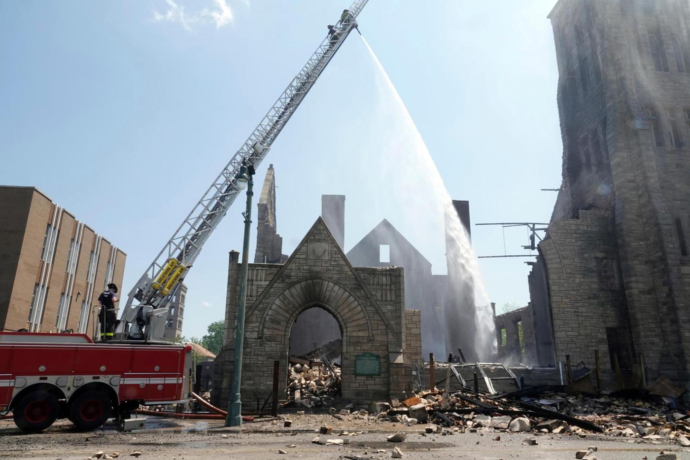
Sunday, May 25, from 4 to 7 p.m. at Venture Bikes Midtown,1000 Midtown Greenway, Minneapolis, Melanin in Motion hosts Slow Roll, Ride to Remember, a narrated biking event that will visit sites “that were central to the community response” to the murder of George Floyd. These sites include George Floyd Square, the Midtown Exchange building, Powderhorn Park, the former site of the 3rd Precinct police station and 3030 Nicollet Ave., where a Wells Fargo branch burned. A community meal and conversation will follow the bike ride from 7:30 to 8:30 p.m. This event is free and bikes can be provided if needed, though they are limited. For tickets, search for Melanin in Motion at eventbrite.com.