
By ALLEN G. BREED and JOHN SEEWER, Associated Press
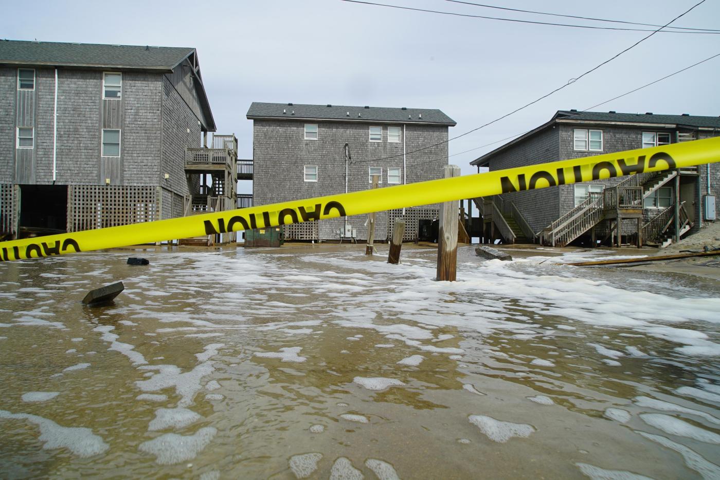
RODANTHE, N.C. (AP) — Hurricane Erin battered North Carolina’s Outer Banks with strong winds and waves that flooded part of the main highway and surged under beachfront homes as the monster storm slowly began to move away from the East Coast on Thursday.
Forecasters predicted the storm would peak Thursday and said it could regain strength and once again become a major hurricane, Category 3 or greater, but it was not forecast to make landfall along the East Coast before turning farther out to sea.
Tropical storm conditions were in effect over parts of the Outer Banks and the coast of Virginia, the National Hurricane Center in Miami said. In Bermuda, residents and tourists were told to stay out of the water with rough seas expected through Friday.
As Erin’s outer bands brushed the Outer Banks, water poured onto the main route connecting the barrier islands and a handful of stilted homes precariously perched above the beach. By Wednesday evening, officials had closed Highway 12 on Hatteras Island as the surge increased and waves rose. The road remained closed Thursday. Ocracoke Island’s connection to its ferry terminal was cut off.
Authorities predicted that the largest swells during high tide would cut off villages and homes on the Outer Banks and whip up life-threatening rip currents from Florida to New England.
Beaches were closed to swimming Wednesday and Thursday in New York City, and some others in New Jersey, Maryland and Delaware were temporarily off-limits. Widespread, moderate coastal flooding was forecast for low-lying areas of Long Island and parts of New York City.
Off Massachusetts, Nantucket Island could see waves of more than 10 feet this week. But the biggest threat remained along the Outer Banks where longtime residents didn’t seem too concerned.
This image provided by the National Oceanic and Atmospheric Administration (NOAA) shows Hurricane Erin on Wednesday, Aug. 20, 2025. (NOAA via AP)
“I remember taking canoes out of my front yard to get to school, so I don’t think it’s gonna be that bad,” said Jacob Throne, who lives on Hatteras Island and works for surf shops.
Despite beach closures elsewhere, some swimmers continued to ignore the warnings. Rescuers saved more than a dozen people caught in rip currents Tuesday at Wrightsville Beach in North Carolina, a day after more than 80 people were rescued.
Bob Oravec, a National Weather Service forecaster, said that even if someone thinks they know how to handle a rip current, it’s not safe.
“You can be aware all you want,” he said. “It can still be dangerous.”
A combination of fierce winds and huge waves estimated at about 20 feet could cause coastal flooding in many beachfront communities, North Carolina officials warned.
“Dangerous conditions can be felt far from the eye, especially with a system as large as Erin,” said Will Ray, the state’s emergency management director.
Dozens of beach homes already worn down from chronic erosion and protective dunes could be at risk, said David Hallac, superintendent of the Cape Hatteras National Seashore.
Most residents decided to stay despite evacuations ordered on Hatteras and Ocracoke Islands.
Related Articles
Today in History: August 21, total solar eclipse captivates America
Tortoise hatchlings born of century-old parents come out of their shells at Philadelphia Zoo
Parents of kids swept away in Texas floods beg lawmakers to protect future campers
Microsoft employee protests lead to 18 arrests as company reviews its work with Israel’s military
Man charged with killing an ‘American Idol’ exec and husband will undergo mental evaluation
“We probably wouldn’t stay if it was coming directly at us,” said Rob Temple, who operates sailboat cruises on Ocracoke.
His biggest concern was whether the main route would wash out and if tourists and delivery trucks may be cut off from the thin stretch of low-lying islands, which are increasingly vulnerable to storm surges.
Erin has become an unusually large and deceptively worrisome system, with tropical storm-force winds spreading across 500 miles — roughly the distances from New York City to Pittsburgh.
It remained a Category 2 hurricane early Thursday with maximum sustained winds around 105 mph, the hurricane center said. Erin was about 205 miles east-southeast of Cape Hatteras and moving north-northeast at 17 mph.
The hurricane center was also watching two tropical disturbances far out in the Atlantic that could develop into named storms in the coming days. With thousands of miles of warm ocean water, hurricanes known as Cape Verde storms are some of the most dangerous that threaten North America.
Climate scientists say Atlantic hurricanes are now much more likely to rapidly intensify into powerful and catastrophic storms, fueled by warmer oceans.
Seewer reported from Toledo, Ohio. Associated Press journalists Jeffrey Collins in Columbia, South Carolina; Gary Robertson in Raleigh, North Carolina; Ben Finley in Norfolk, Virginia; Dave Collins in Hartford, Connecticut; Hallie Golden in Seattle; and Julie Walker in New York contributed to this report.
Leave a Reply