
We forget what we don’t want to remember. While I understand that impulse, there are dangers embedded in our forgetfulness. This is especially true for anyone living in Flash Flood Alley, or what we like to call the Hill Country (a concept that softens the nature of this flood-sculpted and -scoured terrain). So I have come to believe after nearly thirty years of thinking, researching, and writing about the September 1921 flood which ravaged Central and South Texas; it killed at least 224 people, and, in its devastated epicenter, San Antonio, 80 or more perished. Yet those who survived that flood were surprised to learn that the Alamo City endured an even larger-in-size (though less fatal) inundation in 1819. There was little to no public memory. People did not die solely because of forgetfulness but because this amnesia allowed succeeding generations to erase the past and their responsibilities to the future. When they could have enacted post-flood, life-saving interventions, they chose not to act on their progeny’s behalf.
Here’s hoping that does not hold true for the most recent disaster, the swift and punishing rise of the Guadalupe River over the July Fourth weekend. It swept away well more than 100 children and adults, a horrific tally which may never be known in full. As with the 1921 flood, when public officials admitted that some bodies might not be recovered, interred as they were beneath tons of silt, gravel, rock, and other debris, so, too, with the Guadalupe. “We don’t know where they are,” Kerr County Judge Rob Kelly acknowledged. We don’t know how many we’ve lost.” That uncertainty intensifies the anguish even as it testifies to this flood’s catastrophic impact. (Mercifully, the official missing persons count was reduced over the past weekend from around 100 to three largely due to individuals being confirmed safe.)
But there is nothing unknown about what triggered the brutal 2025 flood and so many others dating back to the nineteenth century (when the first, if spotty, records were kept). Some of the explanation results from where the Guadalupe—like the Colorado and San Gabriel rivers to its north, and the San Antonio to its south—originate. Their tributaries rise in the rugged Edwards Plateau, the massive landform whose 24-million acres dominate and define Central Texas. Although the plateau’s elevation is modest, with its eastern sectors varying from 800 to 1200 feet above sea level, this range in height is less important than its relation to the very gulf waters against which the plateau is measured.
Put a pin next to the source of your local (or favorite) watershed, then follow it as it streams south and east on its run to the Gulf of Mexico. Find the nearest beach, put your feet in the water. If it feels like a hot tub, you are in the right place. In mid-July, for instance, water temperatures at Port Aransas measured between 82-84°F. This heat index becomes the second datapoint essential to understanding the thunderous storms that have blown up over the Edwards for millennia.
The third is the prevailing breezes that capture the steamy moisture rising off the gulf and, in counter-flow to the rivers, sweep north and west slowly rising with the coastal plain. It is a relatively gentle climb—San Antonio sits 650 feet above sea level, New Braunfels at 630, and Austin at 489. But almost immediately to the northwest, gentle turns steep. That’s because this wet air hits the Balcones Escarpment, a geological structure of faults that curves northeast from Del Rio to Waco. It marks a sharp increase in elevation: Though they have the Guadalupe River in common, Kerrville is 1,000 feet higher than New Braunfels.
And what a difference the upcountry makes. As that moisture-packed airflow swirls aloft, it hits cooler temperatures and begins to condense and fall, then reheat and rise again, a cycle of convection that as it repeats can generate thunderheads. Should this volatile mixture collide with a cold front, the whole might explode. That’s how C. Terrell Bartlett, a San Antonio-based engineer, explained the 1921 flood to the annual conference of the American Society of Civil Engineers one month after it tore through South and Central Texas: “It has long been recognized that in many cases the sudden rise at the Balcones Escarpment causes intense precipitation along and just above its margin.” What they knew then, we must recall now.
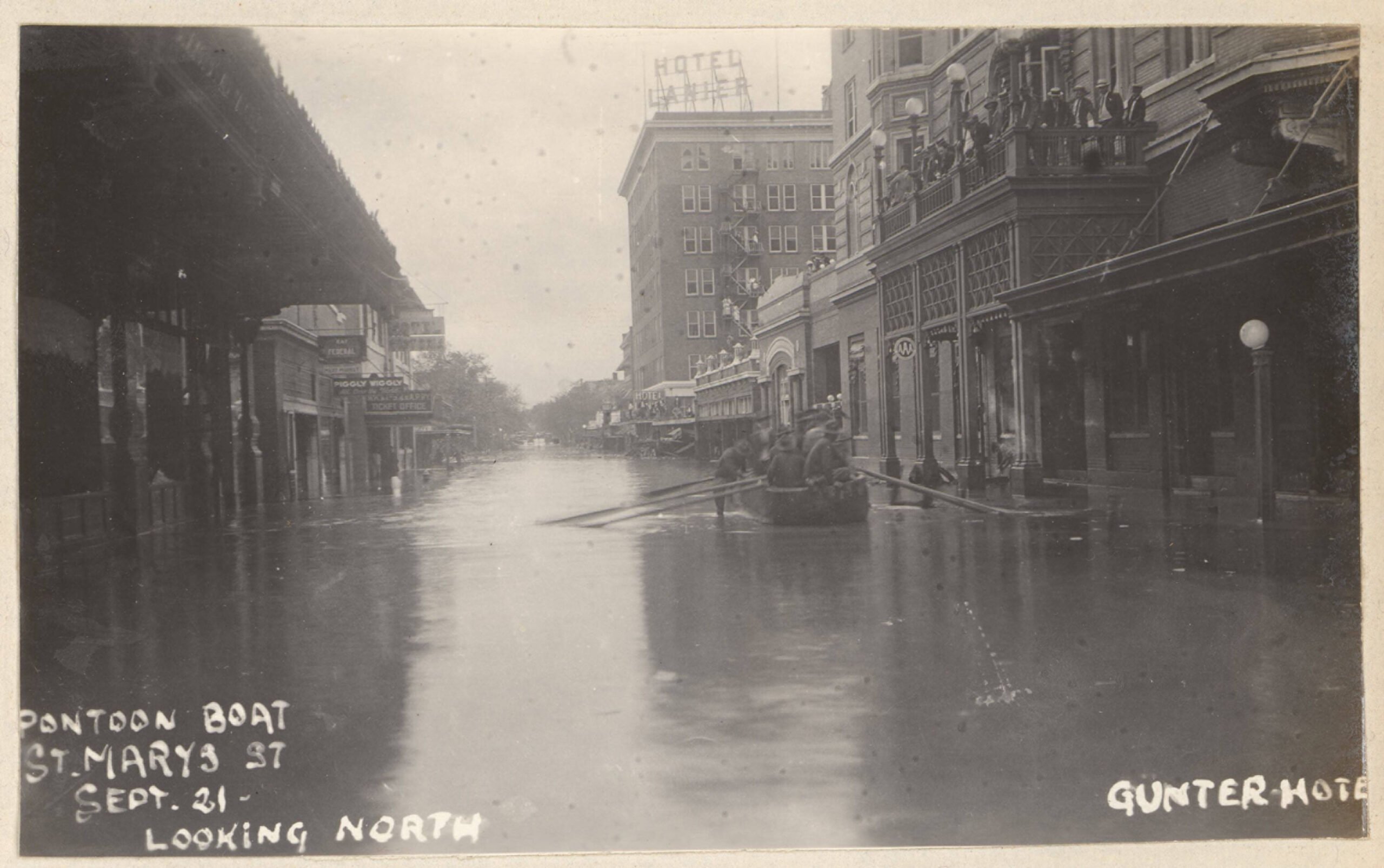
United States Army soldiers assisting with search-and-rescue operations using a pontoon boat on Saint Mary’s Street by the Gunter Hotel following the 1921 flood (Coates Library Digital Collections, Trinity University, San Antonio)
We also need to recollect that the atmospheric-disturbing escarpment is key to why the Hill Country is so flood-prone. Every storm—whatever its size and power—has dumped rain that over thousands of years has carved channels into the limestone bedrock to sluice water downhill, an erosive force that has created some of the very aesthetic features—braided riverbeds, steep-walled canyons, and breathtaking views—that have drawn so many to this rough terrain. Farther downstream, the alluvial actions of these riparian systems, even at normal flow, have carried critical nutrients downstream. At flood-stage, these biotic riches have been dispersed across and built up floodplains, reenergized wetlands, and nurtured habitats. Rivers’ sustaining pulse, their dynamic and regenerative influences, are key to James Scott’s brilliant and posthumously published In Praise of Floods (2025). Its opening sentence—“Rivers, on a long view, are alive”—testifies that they are as well the life-source for all species.
The Indigenous people of what is now Texas understood this concept full well. They knew that the dangers we associate with Flash Flood Alley were indistinguishable from the manifold benefits floodwaters bore. They were just smarter about how to live within a river’s embrace, siting their communities near springs and adjacent to fertile floodplains but always above historic high-water levels. Missing that long-lived insight were Spanish, and later Mexican and American, colonists, whether Canary Islanders, German émigrés, or white enslavers. These settlers depended on sedentary agriculture that led them to plow and dig their communities into the flood zones of the San Antonio, Guadalupe, and Colorado rivers.
Controlling floods, not shifting the pattern of settlement to safer ground, became the ambition every time San Antonio was inundated. Beginning in the 1850s, local engineers and a handful of public officials urged the construction of a flood-retention dam to bottle up the city’s eponymous river north of the downtown core. It would take seventy years and countless deadly floods for that structure to gain taxpayer approval in 1921; it would take until the 1970s, and a lot of grassroots protests on the city’s vulnerable West Side, a sector that the 1921 flood destroyed, to gain protective infrastructure.
Austin was faster off the mark. In 1893, after years of enduring a rain-swollen Colorado jumping its banks and ravaging the community, the city, using its municipal tax and bond powers, built a sixty-foot high, 1900-foot-long, granite-block dam. The structure took advantage of the river’s historic path. “The Colorado above Austin follows in a deep cut or canyon worn in the limestone rock,” wrote UT-Austin geologist Thomas U. Taylor. “It is skirted by limestone bluffs rising often to the height of 150 feet above the bed of the river, broken by the erosion of tributary streams. No extensive meadow or bottom lands exist. This situation permits the construction of a high dam with but little damage to private property.” Under ordinary circumstances, the Colorado occupied only a small part of the channel, but in “great floods the river spreads from bluff to bluff.” In 1900, after a series of massive storms, the Colorado slammed into the structure, overtopping and undercutting it, killing dozens. Its spectacular failure, Taylor asserted, was due to ignorance of the site’s geology, poor engineering, and political interference, and one other factor: silt. The river carried so much grit downstream that it acted as a gigantic sandblaster, and the structure broke before the churning onslaught.
William L. Bray, one of Taylor’s university colleagues, wondered whether there was a human component to the speed and debris-packed floodwaters. A botanist, Bray received a contract from the U.S. Bureau of Forestry to report on the “Timber of the Edwards Plateau of Texas” (1904). Before you yawn, note that the report’s subtitle offered a more ecological analysis of woody vegetation’s “Relations to Climate, Water Supply, and Soil.” With that encompassing objective, Bray roamed the Balcones Escarpment and the wider plateau and paid close attention to how people were using axe and animals to eke out their living in the thin-soiled landscape.
Cedar choppers were hard at work harvesting for fencing and fuel; sheep, goat, and cattle were grazing on what grasses were available. These economic activities came with considerable environmental costs, Bray argued after studying two canyons linked to the Colorado River. One of them retained its thicket of vegetation; the other had been stripped clean. Unlike the first, which acted like a sponge during rain events, the denuded slopes of the other did little to restrain precipitation from racing downhill, “to pour down as from a steep roof converging into swift streamlets which erode every vestige of organic soil.” This load, along with other heavier debris, then crashed into already roiling tributaries, the whole becoming a “mountain torrent.” The Colorado floodwaters, with their anthropogenic and natural sources, continued to run free until the 1940 completion of Austin’s Tom Miller Dam. Its funding, not incidentally, came from the New Deal’s Public Works Administration, a $2.3 million gift that the Hill Country’s native son, then-Representative Lyndon B. Johnson, had secured.
To date, that initial investment and subsequent infrastructure projects that the Lower Colorado River Authority manages have protected communities within the larger watershed under most conditions. But what just happened on the Guadalupe—and had occurred on the San Antonio in 1921—was not “most conditions.” Let’s return then to the Gulf of Mexico and its simmering saltwater. Add to its hot-to-the-touch condition an atmosphere containing elevated levels of humidity and crucially the absence of strong, shearing winds. Overhead powerful thunderstorms might begin to form. As they do, they suck up more warm moisture into a spiraling system. The pressure begins to drop which pulls in more wind, and if these conditions hold a tropical depression might morph into a tropical storm or hurricane. Recent research connects the dots between this formative process and ocean surface temperatures: “warmer waters,” NOAA notes, “fuel more energetic storms.”
The surface and lower depths of the Gulf were not nearly as hot a century ago as they are today, a difference attributable to climate-disrupting, planetary warming; climate change is an accelerant, boosting and intensifying a pre-existing weather pattern. One of those earlier storms, a strong tropical depression that formed in the gulf in early September 1921, slowly spun towards northern Mexico, and on September 7th it came ashore south of Tampico. Over the next three days, it cycled across the Rio Grande into Webb County, then drifted along the Balcones Escarpment to rain down over Bexar, Comal, Hays, and Travis counties before pounding Williamson, Bell, and Milam. The U.S. Weather Bureau could not formally verify “the distribution of the pressure” that directed the storm’s path, yet it insisted that “the shifting winds, the progressive northeastward extension of the rainfall area, and the profound agitation of the atmosphere as evidenced by violent squalls and thunderstorms over the stricken section can hardly be ascribed to any other cause.”
San Pedro Creek near Commerce Street following the 1921 flood (Coates Library Digital Collections, Trinity University, San Antonio)
Contemporaries recorded two significant results of the 1921 deluge. Because San Antonio was the “most densely populated and most highly developed community affected by the flood,” it received “the most widespread notice in the press.” Yet its attention-grabbing devastation needed context, C.E. Ellsworth, a USGS researcher, averred. If the “rainfall in the basin of San Antonio River had been as heavy as it was in much of the basin of Little River, in Bell, Milam, and Williamson counties, the destruction at San Antonio would have been so great as to make that actually suffered there seem insignificant.” That’s why the “aggregate loss of both life and property in other areas far exceeded that at San Antonio,” though who died in the various flood zones was consistent. Most were “Mexicans who lived in poorly constructed houses, built along the low banks of the streams. Undoubtedly many others were drowned who were never reported missing,” Ellsworth wrote, and along the “Little and San Gabriel rivers bodies were found six months or more after the flood.”
Some of this analysis is hauntingly familiar. The pile-driving origin of the 2025 inundation in Kerr County was yet another tropical disturbance—dubbed Barry—that made landfall in northern Mexico and headed across the border where later it slammed into already saturated skies whirling above the Edwards Plateau. As with the 1921 storm, during which record-setting whiteout downpours hit the upper reaches of the San Antonio River and the middle stretches of the San Gabriel—39 inches fell at Thrall—some parts of the Guadalupe watershed had more than 15 inches hammer down so fast that the river itself rose 26 feet within less than an hour. That’s a predictable result of the tight confines through which escarpment rivers squeeze.
As foreseeable, alas, is the disaster that results if this torrent powers into urban streets or a rural camp called Mystic.
Neither flood could have been prevented. It is a river’s nature to flood. But the human-made disasters that resulted could have been mitigated. The Dallas Morning News spoke to this in a September 13, 1921, editorial, “Flood Yet to Come,” observing that “the most distressing feature of San Antonio’s disastrous flood experiences is the probability that they were avoidable. It does not seem unreasonable that foresight could have prevented the great loss of life and property” and proof that it was “preventable will come in the decision to take steps at once to prevent the recurrence of the catastrophe.” Solutions could have been proactively implemented. The state was duly forewarned: “Scarcely is there a city of any size in Texas,” the News continued, “but has within its confines one or more placid water course potentially as murderous as the beautiful San Antonio River.”
The post The San Antonio Flood of 1921 Held Lessons We Refuse to Learn appeared first on The Texas Observer.
Leave a Reply